
An aerial photograph of Christchurch following the 4 September earthquake, taken from a helicopter.

An aerial photograph of Christchurch following the 4 September earthquake, taken from a helicopter.

An aerial photograph of Christchurch following the 4 September earthquake, taken from a helicopter.

An aerial photograph of Christchurch following the 4 September earthquake, taken from a helicopter.

An aerial photograph of Christchurch following the 4 September earthquake, taken from a helicopter.

An aerial photograph of Christchurch following the 4 September earthquake, taken from a helicopter.

An aerial photograph of Christchurch following the 4 September earthquake, taken from a helicopter.

An aerial photograph of Christchurch following the 4 September earthquake, taken from a helicopter.

An aerial photograph of Christchurch following the 4 September earthquake, taken from a helicopter.

An aerial photograph of Christchurch following the 4 September earthquake, taken from a helicopter.

An aerial photograph of Christchurch following the 4 September earthquake, taken from a helicopter.

An aerial photograph of Christchurch following the 4 September earthquake, taken from a helicopter.

An aerial photograph of Christchurch following the 4 September earthquake, taken from a helicopter.

An aerial photograph of Christchurch following the 4 September earthquake, taken from a helicopter.

An aerial photograph of Christchurch following the 4 September earthquake, taken from a helicopter.

Photograph captioned by Fairfax, "Damage to Christchurch CBD buildings after the September 4th earthquake. The MLC building on Manchester Street".

This beautiful building on Madras Street is red stickered and may be condemned if the structural damage it suffered in the magnitude 7,1 earthquake on Saturday 4 September 2010 cannot be repaired.

This beautiful building on Madras Street is red stickered and may be condemned if the structural damage it suffered in the magnitude 7,1 earthquake on Saturday 4 September 2010 cannot be repaired.

This beautiful building on Madras Street is red stickered and may be condemned if the structural damage it suffered in the magnitude 7,1 earthquake on Saturday 4 September 2010 cannot be repaired.

One landscape colour digital photograph taken on 15 June 2011 showing earthquake damage to the Anglican Church of The Most Holy Trinity in Winchester Street, Lyttelton. Photograph shows collapsed roof of the nave and north transept. Photograph taken from the north side of the church. Architect The collapse of the Church of the Most Holy Trinity ...
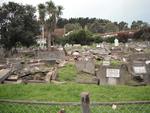
One landscape colour digital photograph taken on 30 June 2011 showing earthquake damage to graves in Lyttelton Roman Catholic and Dissenters (Public) Cemeteries in Reserve Terrace. Most of the headstones and grave surrounds in the photograph show damage. Looking east in the Dissenters (Public) section of the cemetery. The Lyttelton cemeteries a...

One landscape colour digital photograph taken on 30 June 2011 showing earthquake damage to a section of retaining wall in Sumner Road. Plastic sheeting installed to stabilise previous damage and protect from water erosion is visible to the right of the photograph. Also visible in the photograph is a boarded up broken window and temporary safety ...

One landscape colour digital photograph taken on 15 June 2011 showing earthquake damage to the Anglican Church of The Most Holy Trinity in Winchester Street, Lyttelton. Photograph shows collapsed roof of the nave and north transept. Photograph taken from the northwest corner of the church. Architect The collapse of the Church of the Most Holy Tr...

A colour photograph of the Fisher's Building, seen from the corner of Lichfield and High Streets. The photograph was taken before the 4 September 2010 earthquake.

One landscape colour digital photograph taken on 19 November 2011 looking east from Norwich Quay from approximately the base of Canterbury Street. Visible in the photograph are the partially deconstructed former Lyttelton Harbour Board Offices, the Holcim Cement Silos, the Oxford Street Railway Overbridge, Lyttelton Port of Christchurch's storag...
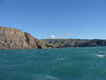
One landscape colour digital photograph taken on 26 May 2013 off Godley Head looking north to Boulder Bay and Taylors Mistake. Rock which fell from the cliffs is heaped at the waters edge. Volcanic banding is visible in the face of the cliffs. There were several major rock falls along the coastal cliffs near Christchurch and Lyttelton Harbour....

One landscape colour digital photograph taken on 26 May 2013 off Godley Head looking north towards Sumner Head. There were several major rock falls along the coastal cliffs near Christchurch and Lyttelton Harbour. In and around the suburb of Sumner some of these falls necessitated the abandonment of houses in areas where cliffs had given way or...

One landscape colour digital photograph taken on 19 November 2011 showing the alleyway next to 29 London Street. These steps provided access to the Wunderbar and the Monsta Bar (closed). Visible to the left is the Lyttelton Coffee Company building being repaired. Prior earthquake strengthening enabled the Lyttelton Coffee Company to undertake w...

One landscape colour digital photograph taken on 19 November 2011 showing part of the north side of London Street. The properties visible from left to right are Lyttel Piko Organic and Wholefoods, and Satchmo Café Pizzabar The Lyttelton streetscape has changed dramatically from its pre-earthquake appearance and will continue to change as new bu...

One portrait colour digital photograph taken on 19 November 2011 showing a poster advertising the planned 2011 Census which was scheduled for Tuesday 8 March 2011. The census was abandoned because of the 22 February 2011 Earthquake. The poster was located in the window of the Lyttelton Information Centre on Oxford Street. The building was closed...