
A photograph of the earthquake damage to the roof of the former Municipal Chambers Building on Oxford Terrace.

A photograph of the severe damage to Cashmere Road in Halswell caused by the 4 September 2010 earthquake.

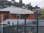
Photograph captioned by BeckerFraserPhotos, "Earthquake damage at 7 Kinsey Terrace. This area is now white zoned".

A photograph of the earthquake-damaged Flexiweld building on the corner of St Asaph Street and Barbadoes Street.

A colour photograph showing the damage around the entrance to Kenton Chambers after the 22 February 2011 earthquake.

Photograph captioned by Fairfax, "Damaged building on Colombo Street in Sydenham after the earthquake on 4 September 2010".

A photograph of the severe damage to Cashmere Road in Halswell caused by the 4 September 2010 earthquake.

Photograph captioned by Fairfax, "Dudley Cridge from Kirwee with his grain silos, which were damaged in Saturday's earthquake".

A photograph captioned by BeckerFraserPhotos, "Earthquake damage to the Catholic Convent on Exeter Street in Lyttelton".

A colour photograph showing damage to the former City Council Civic Offices following the 22 February 2011 earthquake.

A photograph of the earthquake-damaged Flexiweld building on the corner of St Asaph Street and Barbadoes Street.

A photograph of the earthquake-damaged Flexiweld building on the corner of St Asaph Street and Barbadoes Street.

A photograph of the earthquake damage to the second storey of Liberty Books at 145-147 Manchester Street.

A photograph of a broken chimney from an earthquake-damaged property lying on the footpath against a tree.

Photograph captioned by BeckerFraserPhotos, "Earthquake damage at 7 Kinsey Terrace. This area is now white zoned".

Photograph captioned by Fairfax, "Aerial pictures of earthquake damage in Christchurch. Corner of Victoria Street and Bealey Avenue".

A photograph of the earthquake-damaged Flexiweld building on the corner of St Asaph Street and Barbadoes Street.

The damage to Castle Rock, overlooking the Heathcote Valley from the 7.1 earthquake on September 4th.

USAR personnel in front of Henry Africa's on Stanmore Road. Bricks have fallen from the upper storey onto the road below, and the building is cordoned off with emergency tape. The photographer comments, "Damage to Henry Africa's restaurant in Stanmore Rd".

Internal damage to a house in Richmond. A step between two rooms has separated from the lower room's floor, leaving a large gap. The photographer comments, "The step down to our sun room is now above the floor".

Damage to a house in Richmond. Part of a concrete patio has slumped, leaving large cracks. In the background, cracks are visible in the brickwork of the house. The photographer comments, "Cracking in the concrete patio".

Christ Church Cathedral has been granted a stay of execution after a High-Court ruling today to stop the planned demolition of the earthquake-damaged Christchurch central landmark.

This shop on Riccarton Road was badly damaged in the magnitude 7.1 earthquake that struck Christchurch on Saturday 4 September 2010, and had to be demolished.

Damaged roof has rendered this pub on Madras Street unsafe in the aftermath of the magnitude 7.1 earthquake that hit Christchurch on Saturday 4 September 2010.

Text across the top of the cartoon reads 'When the luck ran out' and shows a disintegrating building that includes two dice with a skull and crossbone on one facet. Context - On 22 February 2011 at 12:51 pm (NZDT), Christchurch experienced a major magnitude 6.3 earthquake, which resulted in severe damage and many casualties. A National State of Emergency has been declared. This followed on from an original magnitude 7.1 earthquake on 4 September 2010 which did far less damage and in which no-one died.
Quantity: 1 digital cartoon(s).

One portrait colour digital photograph taken on 25 February 2011 showing damage to the Old Post Office Building on the Corner of Norwich Quay and Oxford Street. Architect The archaeological investigation of the site of the old Lyttelton Post Office uncovered evidence of Maori settlement in the area including a midden, fire places and an adze. Th...

One landscape colour digital photograph taken on 25 February 2011 showing damage to the Norton Buildings on Oxford Street. The photograph shows part of the first floor of the building and the façade collapsed onto the ground floor and out onto the street. The photograph was taken from St Davids Street looking west. Also visible in the photogra...

One portrait colour digital photograph taken on 25 February 2011 showing damage to the Plunket Rooms on Sumner Road. Also visible in the photograph are the rear of the former Library and Fire Station, 2 London Street and the eastern end of The Church of the Most Holy Trinity. When the Lyttelton Plunket Rooms were demolished in July 2012, archae...
One landscape colour digital photograph taken on 27 April 2011 showing damage to the Old Post Office Building on the corner of Norwich Quay and Oxford Street. The old Telegraph office located beside the Old Post Office and the Timeball Station are also visible. Architect As Lyttelton's first main street, Norwich Quay was the site of many early g...

Damage to Christchurch city following the 22 February earthquake 2011. A car sits in a hole created by liquefaction on Ferry Road. Piles of silt can be seen around the car.