
One landscape colour digital photograph taken on 16 June 2011 showing the site of the Timeball Station after its collapse. Part of the ground floor remains visible. Photograph taken from Oxford Street Overbridge. Architect The 13 June 2011 earthquakes caused the collapse of the already damaged Lyttelton Timeball Station. After the 22 February ...
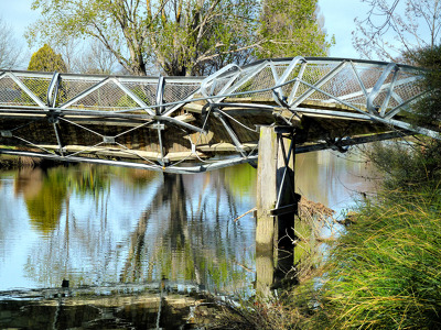
The badly twisted Medway Street footbridge. The photographer comments, "The September 4th 2010 earthquake in Christchurch was so violent that the banks of the Avon River moved towards each other. This footbridge being metal had to twist sideways to release the pressure of being pushed from both river banks. It looked like it had been wrung out like a wet towel".

Photograph captioned by Fairfax, "The historic Duvauchelle pub has been badly damaged after September 4th earthquake".

Photograph captioned by Fairfax, "The historic Duvauchelle pub has been badly damaged after September 4th earthquake".

Photograph captioned by Fairfax, "The historic Duvauchelle pub has been badly damaged after September 4th earthquake".

The latest (but temporary) tourist attraction in mid-Canterbury! This was the previously unknown faultline where the Saturday 4 September 2010 earthquake originated.

Photograph captioned by Fairfax, "The new Christchurch Council building has suffered only cosmetic damage in the September 4th earthquake".

One framed certificate issued to SCIRT in 2013 to mark winning The Press Champion Canterbury Supreme Award in the Medium-Large Enterprise category.
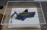
One oblong perspex covered 3-D model of the fault plains associated with the 4 September 2010 Darfield earthquake; top of the model also acts as a map overlay. Geologists continue to study the 4 September 2010 earthquake and consider it is likely to have been a complex event with several faults rupturing simultaneously. This model provides one ...

One carved wooden lintel that decorated a doorway at Hadleigh House. Features a cross on shield motif. Owner of Hadleigh House 1904-1921

A colour photograph of the west facade of the Excelsior Hotel, taken after the September 4th earthquake.

Toppled grain silos on the outskirts of Darfield near the epicentre of the magnitude 7,1 earthquake that struck on Saturday 4 September 2010.

Toppled grain silos on the outskirts of Darfield near the epicentre of the magnitude 7,1 earthquake that struck on Saturday 4 September 2010.

Toppled grain silos on the outskirts of Darfield near the epicentre of the magnitude 7,1 earthquake that struck on Saturday 4 September 2010.

Toppled grain silos on the outskirts of Darfield near the epicentre of the magnitude 7,1 earthquake that struck on Saturday 4 September 2010.

Toppled grain silos on the outskirts of Darfield near the epicentre of the magnitude 7,1 earthquake that struck on Saturday 4 September 2010.

Toppled grain silos on the outskirts of Darfield near the epicentre of the magnitude 7,1 earthquake that struck on Saturday 4 September 2010.

Toppled grain silos on the outskirts of Darfield near the epicentre of the magnitude 7,1 earthquake that struck on Saturday 4 September 2010.

Toppled grain silos on the outskirts of Darfield near the epicentre of the magnitude 7,1 earthquake that struck on Saturday 4 September 2010.

Toppled grain silos on the outskirts of Darfield near the epicentre of the magnitude 7,1 earthquake that struck on Saturday 4 September 2010.

Toppled grain silos on the outskirts of Darfield near the epicentre of the magnitude 7,1 earthquake that struck on Saturday 4 September 2010.

Efforts are being made to shore up and strengthen this building (corner of Hereford Street / Manchester Street) to save it from demolition after it suffered structural damage in the magnitude 7.1 earthquake that struck Christchurch on Saturday 4 September 2010.

Efforts are being made to shore up and strengthen this building (corner of Hereford Street / Manchester Street) to save it from demolition after it suffered structural damage in the magnitude 7.1 earthquake that struck Christchurch on Saturday 4 September 2010.

Rolleston/Burnham, South Island, NZ
It's been a busy few weeks! Was away on geology fieldtrips all the previous two weeks, then on Saturday morning 4th September 2010 at 4.35 am we got woken in Westport to a reasonable but very long earthquake. My husband was back in Christchurch at the time and texted me saying "are you ok?". I replied, "yes!"...

One landscape colour digital photograph taken on 19 April 2011 showing the demolition of the Empire Hotel on London Street. The photograph shows the façade of the hotel supported by the framework installed to brace the building after the 4 September 2010 earthquake. A crane is being used to enable the east wall to be demolished by hand to avoid...
On the way to Darfield to locate the faultline where the tectonic plates slipped, causing the magnitude 7.1 earthquake on Saturday 4 September 2010.

An aerial photograph of Christchurch following the 4 September earthquake, taken from a helicopter.

An aerial photograph of Christchurch following the 4 September earthquake, taken from a helicopter.

An aerial photograph of Christchurch following the 4 September earthquake, taken from a helicopter.

An aerial photograph of Christchurch following the 4 September earthquake, taken from a helicopter.