
The Iconic Bar, near the corner of Manchester Street and Gloucester Street.

813 Colombo Street looking south-ish, near the corner of Peterborough Street.

YHA Christchurch City Central, 273 Manchester Street, between Armagh Street and Gloucester Street.

Manchester Street looking north-ish, taken from the Gloucester Street intersection.

Montreal Street looking north, near the corner of Hereford Street, Christchurch.

One twisted rectangular metal sign engraved with the words 'Pyne Gould Corporation' in black. Recovered from the Pyne Gould Corporation Building following the 22 February earthquake. The Pyne Gould Corporation (PGC) building, which was located on Cambridge Terrace in central Christchurch, collapsed during the 22 February 2011 earthquake with 18...

Forbe's Store on Norwich Quay, the awning resting on the footpath. Scaffolding placed around the building since the 4 September 2010 earthquake has tumbled during the 22 February 2011 earthquake.

Photograph captioned by Fairfax, "Damage from the February 22nd earthquake in Christchurch. Retaining wall and roof damage on Hackthorne Road, Cashmere".

Photograph captioned by Fairfax, "Damage from the February 22nd earthquake in Christchurch. People queuing and waiting for water at Redcliffs School".

Photograph captioned by Fairfax, "Damage from the February 22nd earthquake in Christchurch. People queuing and waiting for water at Redcliffs School".

Photograph captioned by Fairfax, "Damage from the February 22nd earthquake in Christchurch. People queuing and waiting for water at Redcliffs School".

Photograph captioned by Fairfax, "Damage from the February 22nd earthquake in Christchurch. Rock retaining walls collapsed on Dyers Pass Road, Cashmere".

Photograph captioned by Fairfax, "Damage from the February 22nd earthquake in Christchurch. Rock retaining walls collapsed on Dyers Pass Road, Cashmere".

Photograph captioned by Fairfax, "Damage from the February 22nd earthquake in Christchurch. Rock retaining walls collapsed on Dyers Pass Road, Cashmere".

Photograph captioned by Fairfax, "Damage from the February 22nd earthquake in Christchurch. Rock retaining walls collapsed on Dyers Pass Road, Cashmere".

Members of the Royal New Zealand Air Force Air Security team preparing to evacuate Christchurch rest home residents affected by the 22 February 2011 earthquake.

Red softcover book with a title on the spine and front cover containing the history of the Lyttelton Volunteer Fire Brigade together with the stories of the Brigade relating to the 22 February 2011 earthquake; published by the Lyttelton Volunteer Fire Brigade, Lyttelton, 2012.
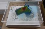
One oblong perspex covered 3-D model of the fault plains that ruptured to cause the 22 February and 13 June 2011 earthquakes; top of the model also acts as a map overlay. This model provides a visual demonstration of the geological forces that caused the 22 February and 13 June 2011 earthquakes. These forces were so strong that parts of the Por...

One landscape colour digital photograph taken on 11 May 2011 showing the town of Lyttelton looking north from the footpath of the Oxford Street Over bridge. The Lyttelton streetscape has changed dramatically from its pre-earthquake appearance and will continue to change as new buildings are erected on empty sections. In this photograph the dome...

The HMNZS Otago moored in Lyttelton. The ship travelled to Lyttelton after the 22 February 2011 earthquake to help in the relief effort.

The HMNZS Otago moored in Lyttelton. The ship travelled to Lyttelton after the 22 February 2011 earthquake to help in the relief effort.
One landscape colour digital photograph taken on 25 February 2011 showing the damage to the former Anglican Vicarage on Ripon Street Lyttelton. Taken from the footpath. Architect The sense of loss felt when confronted with the collapse or demolition of an historic building is compounded when that building is also a home. While the community sees...

One landscape colour digital photograph taken on 11 June 2011 showing the demolition of the old Lyttelton Library, Council Chambers and Magistrates' Court on the corner of Oxford Street and Sumner Road. The photograph shows the upper floor of the building being demolished with a high reach digger. At the time of the 22 February 2011 Earthquake...

One landscape colour digital photograph taken on 16 June 2011 showing the partial demolition of the old Lyttelton Harbour Board Offices on the corner of Oxford Street and Norwich Quay. The photograph shows the temporary roof being constructed over the original ground floor of the building. At the time of the 22 February 2011 earthquake the build...

Christchurch Cathedral, Cathedral Square.

Christchurch Cathedral, Cathedral Square.

One landscape colour digital photograph taken on 28 February 2011 showing the plume of water from a broken water main. The plume appears to be in the vicinity of the Bridle Path. Photograph taken looking west from the corner of Canterbury and Ripon Streets. Repairing infrastructure following the Canterbury Earthquakes has proved to be a complex...

North Hagley Park, Christchurch, New Zealand.
Tens of thousands turned out today to mark the one year anniversary of the devastating earthquake that struck the city at 12.51pm on 22 February, 2011.
185 people lost their lives.
file.stuff.co.nz/stuff/12-51/
Took 4 pa...

Christchurch Mayor Bob Parker being interviewed by TV3 at the Art Gallery/Civil Defence Headquarters.

Colombo Street looking north through Cathedral Square, towards the Port Hills. Taken from Victoria Square.