
Mechanical Engineer students walking between classes at the Ohoka/Mandeville Showground.

A class underway in Avon 205 at the College of Education.

Workers helping to construct the temporary classrooms on the Ilam Oval.

Workers helping to construct the temporary classrooms on the Ilam Oval.

Workers helping to construct the temporary classrooms on the Ilam Oval.

A map showing an area of Canterbury to be aeromagnetically surveyed.

A map showing Green, Orange, Red, and White Zones in Christchurch.

A map showing a proposed memorial area along the Avon River.

A promotion for an interactive online tool for finding new subdivisions.

A map showing Green, Orange, Red, and White Zones in Kaiapoi.
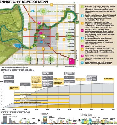
An infographic giving an overview of the draft Central City Plan.

An uncompleted chart showing numbers of performances by the Court Jesters.

A page banner promoting an article titled, "Rapping in the rubble".

A page banner promoting an article about business closures in Sumner.

A page banner promoting an article titled, "Planning a new home".

A graphic to accompany an article titled, "City Council business divide".

A view down Hereford Street to Manchester Street past a cordon checkpoint.

A graphic to accompany a feature on Christchurch's most powerful people.

Photograph captioned by BeckerFraserPhotos, "Kingsford Street".

Photograph captioned by BeckerFraserPhotos, "Avonside Drive".

Photograph captioned by BeckerFraserPhotos, "Ash Street".

Photograph captioned by BeckerFraserPhotos, "Durham Street".

Photograph captioned by BeckerFraserPhotos, "Dublin Street".

Photograph captioned by BeckerFraserPhotos, "Avonside Drive".

Photograph captioned by BeckerFraserPhotos, "Avonside Drive".

A photograph of extensive damage to the Repertory Theatre on Kilmore Street.

Photograph captioned by BeckerFraserPhotos, "Ferry Road".

The collapsed brick wall of a property on Armagh Street.

Photograph captioned by BeckerFraserPhotos, "Linwood Avenue".

A house on The Spur in Clifton.