
A photograph of the earthquake damage to 24 Mariner Street.

A photograph of a damaged building on Tuam Street.

A photograph of hedges sculpted into penguins at Re:START mall.

A compliation of photographs of memorials from around the world.

A tree in blossom in the Botanic Gardens.

A photograph of the earthquake damage to 170 Tuam Street.

A photograph of a damaged building on Tuam Street.

A photograph of the earthquake damage to 119 Worcester Street.

A photograph of repaired cracks on Governors Bay Road.

Photograph looking south along the footpath on Manchester Street.

Building wreckage behind a residential property on Peterborough Street.

A map showing the location of fault lines in Canterbury.

Liquefaction and road damage around properties on Ferry Road in Woolston.

Damage to the former Canterbury Public Library.

A photograph of the earthquake damage to 231 Kilmore Street.

A photograph of a damaged building on Hereford Street.

An infographic about Jane Deans's account of the 1869 earthquake.

A photograph of a detail of 231 Kilmore Street.

A photograph of the earthquake damage to 91 Cashel Street.

A photograph of Dog Park Art Project Space on Wilsons Road

A photograph of the earthquake damage to 18 Bedford Row.

Students at an event to thank the Student Volunteer Army.

A photograph of a detail of 236 Tuam Street.

An infographic showing the proposed site for a rugby field.

A photograph of the earthquake damage to 323 Gloucester Street.

A photograph of a damaged building in Lyttelton.

Graphs comparing residential property prices across Christchurch and New Zealand.
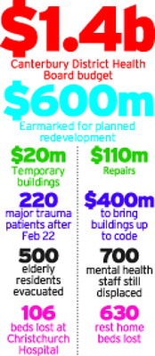
A graphic giving statistics about the Canterbury District Health Board.

Damage to St John the Baptist Church in Latimer Square.

A photograph of the earthquake damage to 116 Cashel Street.