
Taken in Christchurch, New Zealand a few days after the 7.1 earthquake that happened on Saturday September 4.

The 2010 Canterbury time capsule chimney box which will record Canterbury earthquake memories.

The 2010 Canterbury time capsule chimney box which will record Canterbury earthquake memories.

Large cracks along the ground in Kaiapoi, after the September 4th earthquake.

Large cracks in the ground in Kaiapoi, after the September 4th earthquake.
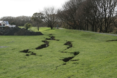
Large cracks in the ground in Kaiapoi, after the September 4th earthquake.

Large cracks along the ground in Kaiapoi, after the September 4th earthquake.

Large cracks along the ground in Kaiapoi, after the September 4th earthquake.

Large cracks along the ground in Kaiapoi, after the September 4th earthquake.

Buckling on a fence in Pines beach, after the September 4th earthquake
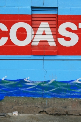
Cracks in the Coastguard Building in Kaiapoi, after the September 4th earthquake.

Large cracks in a skatepark in Kaiapoi, after the September 4th earthquake.
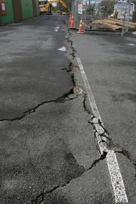
Large cracks in a road in Kaiapoi, after the September 4th earthquake.

Damage to a house in Pines Beach, after the September 4th earthquake.

Large cracks in the ground in Kaiapoi, after the September 4th earthquake.

Photo of earthquake damage in Christchurch taken by James Thompson, 6 September 2010.

Photo of earthquake damage in Christchurch taken by Paul Gofton, 6 September 2010.

Ferry Road, heading towards Redcliffs and Sumner.

Ferry Road, Woolston.

One landscape colour digital photograph taken on 25 February 2011 showing earthquake damage to the Lyttelton Timeball Station. Also visible is damage to some of the houses in the foreground such as temporarily patched holes in roofs where chimneys have fallen. Architect The Lyttelton Timeball Station was completed in 1876. Its function was to p...

One landscape colour digital photograph taken on 16 June 2011 showing the eastern skyline of Lyttelton without the tower of the Timeball Station and Signal Mast. Part of the ground floor remains visible. The Holcim Cement Silos and Lyttelton Port of Christchurch log storage yard are visible in the foreground. Photograph taken from Oxford Street...

One landscape colour digital photograph taken on 19 November 2011 showing the alleyway next to 29 London Street. These steps provided access to the Wunderbar and the Monsta Bar (closed). Visible to the left is the Lyttelton Coffee Company building being repaired. Prior earthquake strengthening enabled the Lyttelton Coffee Company to undertake w...

One landscape colour digital photograph taken on 19 November 2011 showing part of the north side of London Street. The properties visible from left to right are Lyttel Piko Organic and Wholefoods, and Satchmo Café Pizzabar The Lyttelton streetscape has changed dramatically from its pre-earthquake appearance and will continue to change as new bu...

One portrait colour digital photograph taken on 19 November 2011 showing a poster advertising the planned 2011 Census which was scheduled for Tuesday 8 March 2011. The census was abandoned because of the 22 February 2011 Earthquake. The poster was located in the window of the Lyttelton Information Centre on Oxford Street. The building was closed...

One portrait colour digital photograph taken on 19 November 2011 showing the framework of the Lyttelton Coffee Company Building surrounded by safety fencing. On the fencing are election hoardings and an advertisement for Samo, the café established by employees of the Lyttelton Coffee Company. Prior earthquake strengthening enabled the Lyttelton...

One landscape colour digital photograph taken on 26 May 2013 showing the southern cliffs of Godley Head, taken from the middle of the shipping channel. Some earthquake damage to the cliffs is visible. There were several major rock falls along the coastal cliffs near Christchurch and Lyttelton Harbour. At Godley Head these caused damage to the ...

One landscape colour digital photograph taken on 27 May 2013 of London Street in Lyttelton. Taken from Sumner Road looking west across the intersection of London and Oxford Streets. The photograph shows several empty sections and the remaining buildings. The Lyttelton streetscape has changed dramatically from its pre-earthquake appearance and w...
One landscape colour digital photograph taken on 26 May 2013 on the corner of Norwich Quay and Canterbury Street, Lyttelton. The photograph shows the Mitre Hotel surrounded by temporary fencing. Three years after the 2010-2011 earthquakes there are still many uncertainties about which buildings can or will be retained. These buildings, or parts...
One landscape colour digital photograph taken on 26 May 2013 of Lyttelton Main School. The photograph is taken from St Davids Street looking northwest. One of the broader consequences of the 2010-2011 Canterbury earthquakes has been the Ministry of Education’s Shaping Education – Future Direction Review of Schools in the Greater Christchurch Ar...
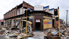
Aftermath of September 4th Earthquake in Canterbury. Shops on Colombo Street in Christchurch - damaged in earthquake and then partially demolished to reduce risk from unstable materials which might otherwise be dislodged in strong winds or subsequent aftershocks. The 1590 aftershocks recorded to date have continued to cause further damage.