Search
found 344 results
Photograph by Neil Macbeth 062
Images, UC QuakeStudies
A man making notes on a map of the Botanic Gardens outside the Robert McDougall Art Gallery. Cracks can be seen in the footpath to his left.
Photograph by Paul Corliss 2240
Images, UC QuakeStudies
A photograph of a city centre map attached to a cordon fence. The photograph is captioned by Paul Corliss, "Crowne Plaza Hotel, corner Kilmore and Victoria Streets. Demolition".
Photograph by Paul Corliss 2242
Images, UC QuakeStudies
A photograph of a city centre map attached to a cordon fence. The photograph is captioned by Paul Corliss, "Crowne Plaza Hotel, corner Kilmore and Victoria Streets. Demolition".
Photograph by Neil Macbeth 063
Images, UC QuakeStudies
A man making notes on a map of the Botanic Gardens outside the Robert McDougall Art Gallery. Cracks can be seen in the footpath to his left.
BeckerFraserPhotos May 2011 photograph 0130
Images, UC QuakeStudies
Photograph captioned by BeckerFraserPhotos, "173 Gloucester Street".
Jennifer Middendorf's Cultural Recovery Centre Photograph 006
Images, UC QuakeStudies
A photograph of material from the Lyttelton Museum's collection being stored on the Canterbury Cultural Recovery Centre's main floor. The collection includes framed pictures and maps, and Navy memorabilia.
Vulnerability to Seismic Hazards in Coastal and Riverside Communities, map…
Images, UC QuakeStudies
A flow chart depicting potential hazards earthquakes pose to coastal geography.
New Zealand Defence Force photograph 673
Images, UC QuakeStudies
A member of the Los Angeles County Fire Department Search and Rescue Team looking at the maps at the entrance to 'Camp Hollywood', the headquarters of the American Civil Defence Forces in Latimer Square. After the 22 February 2011 earthquake, emergency service agencies set up their headquarters in Latimer Square.
New Zealand Defence Force photograph 671
Images, UC QuakeStudies
A member of the Los Angeles County Fire Department Search and Rescue Team looking at the maps at the entrance to 'Camp Hollywood', the headquarters of the American Civil Defence Forces in Latimer Square. After the 22 February 2011 earthquake, emergency service agencies set up their headquarters in Latimer Square.
WEMO ERT Set 3 - February 2011 - Photograph 066
Images, UC QuakeStudies
A photograph of a map used by the Wellington Emergency Management Office Emergency Response Team. The block of buildings between Montreal, Acton, St Asaph, and Antigua Streets has been outlined in red. Halkett Street has also been coloured in red. Various buildings around these areas have been highlighted in orange and blue.
All Right? AWA Trails Aranui Primary School Photograph 1
Images, UC QuakeStudies
A photograph of three Aranui Primary School pupils and an adult looking at a trail map. The photograph was taken at the launch of the Aranui AWA trail at Aranui School.
BeckerFraserPhotos June 2011 photograph 174
Images, UC QuakeStudies
Photograph captioned by BeckerFraserPhotos, "The north-west corner of Manchester and Gloucester Streets (Map World). Extensive frontal collapse of the Gloucester Street frontage during the 13 June 2011 earthquake".
Photo by Jennifer Middendorf 190
Images, UC QuakeStudies
One of the new directions signs at key points around the edge of the cordon, which show a map of the Red Zone and walking times and directions to various landmarks.
WEMO ERT Set 3 - February 2011 - Photograph 068
Images, UC QuakeStudies
A photograph of a map used by the Wellington Emergency Management Office Emergency Response Team. The block of buildings between Montreal, Acton, St Asaph, and Antigua Streets has been outlined in red. Halkett Street has also been coloured in red. Various buildings around these areas have been highlighted in orange and blue.
WEMO ERT Set 3 - February 2011 - Photograph 067
Images, UC QuakeStudies
A photograph of a map used by the Wellington Emergency Management Office Emergency Response Team. The block of buildings between Montreal, Acton, St Asaph, and Antigua Streets has been outlined in red. Halkett Street has also been coloured in red. Various buildings around these areas have been highlighted in orange and blue.
WEMO ERT Team Set 1 - April 2011 - Photograph 1
Images, UC QuakeStudies
A photograph of a map used by emergency management personnel to inspect buildings after the 22 February 2011 earthquake. The block between St Asaph, Antigua, Montreal, and Acton Street has been outlined with a red felt-tip pen. Some of the buildings in the block and below Acton Streets have been coloured orange. A few other buildings have been coloured blue.
BeckerFraserPhotos May 2011 photograph 0970
Images, UC QuakeStudies
Photograph captioned by BeckerFraserPhotos, "267 Manchester Street".
All Right? Buskers Festival Photograph 14
Images, UC QuakeStudies
A photograph of 'All Righties' about to squirt Guy Langford's Captain Cook as he shows his treasure map to a child. The photograph was taken at the 2014 SCIRT World Buskers Festival in Hagley Park.
All Right? AWA Trails Chisnallwood Intermediate Photograph 7
Images, UC QuakeStudies
A photograph of two posters attached to the fence of Chisnallwood Intermediate. The poster on the left shows the AWA Trails map. The poster on the right identifies this spot as Location 1 on the Chisnallwood Trail. The photograph was taken at the launch of the Chisnallwood AWA trail at Chisnallwood Intermediate. All Right? posted the photograph on their Facebook page on 2 September 2015 at 3:56pm.
All Right? AWA Trails Aranui Primary School Photograph 4
Images, UC QuakeStudies
A photograph of two people looking at an AWA Trail map. The photograph was taken at the launch of the Aranui AWA trail at Aranui School. All Right? posted the photograph on their Facebook page on 2 September 2015 at 3:55pm.
Photograph by Neil Macbeth 157
Images, UC QuakeStudies
Civil Defence staff conferring at their headquarters in the Christchurch Art Gallery during the immediate aftermath of the 22 February earthquake. On the back wall maps of the city on which areas of importance have been marked with stickers and marker pens can be seen.
WEMO ERT Set 3 - February 2011 - Photograph 103
Images, UC QuakeStudies
A photograph of cars on Manchester Street which has been crushed by falling rubble. Bricks and other rubble from the earthquake-damaged shops above are scattered across the road in front. The word "clear" has been spray-painted on the side of the cars.
BeckerFraserPhotos September 2011 photograph 566
Images, UC QuakeStudies
Photograph captioned by BeckerFraserPhotos, "Intersection of Gloucester and Manchester Streets (north-west view)".
New Zealand Defence Force photograph 669
Images, UC QuakeStudies
The entrance to 'Camp Hollywood', the American Civil Defence Force headquarters in Latimer Square. After the 22 February 2011 earthquake, emergency service agencies set up their headquarters in Latimer Square. The entrance way has a wooden sign reading, "Camp Hollywood" and a series of maps of Christchurch and New Zealand.

Book: Trapped, Remarkable Stories of Survival from the 2011 Canterbury Ear…
Images, Canterbury Museum
One multi-coloured softcover book titled 'Trapped' by Martin van Beynen with colour illustrations and maps. Collected experiences of some of those trapped following the 22 February earthquake. Mainstream media coverage of the 22 February 2011 earthquake understandably focussed on the devastating damage and loss of life caused by the earthquake....

Book: The Big Quake, Canterbury September 4, 2010
Images, Canterbury Museum
Multicolour softcover book titled "The Big Quake, Canterbury September 4, 2010" by The Press; colour illustrations and maps; accompanying DVD. The extent of the damage caused by the 4 September 2010 earthquake is recorded in this book by Christchurch’s daily newspaper The Press. The overall message portrayed is one of community spirit and a com...
All Right? AWA Trails St James School Photograph 2
Images, UC QuakeStudies
A photograph of four St James School pupils presenting the AWA Trails project. One of the pupils (centre-right) holds an AWA Trails map. The photograph was taken at the launch of the St James AWA Trail at St James School. All Right? uploaded the photograph to their Facebook Timeline on 2 September 2015 at 3:56pm.

Sign: Cokers Hotel
Images, Canterbury Museum
One metal backed plastic sign, circa 1970s, for Cokers Hotel, Manchester Street, Christchurch detailing hotel services and featuring a map of the central city. The Cokers Hotel was located in central Christchurch at 52 Manchester Street. First licensed by John Etherdan (Jack) Coker in 1867, in 1890 the lease was taken over by Captain Popham, wh...

Commemorative Badge: Australian Emergency Services, Christchurch Earthquak…
Images, Canterbury Museum
One red and black plastic-backed fabric uniform badge commemorating the Christchurch earthquake; badge has a red background with a black circular inset inside of which is a map of New Zealand in white with red concentric circles emanating from the Canterbury region. Across the top run the words 'Christchurch Earthquake 2011' and along the bottom...
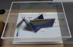
3-D Model: Greendale and Associated Faults
Images, Canterbury Museum
One oblong perspex covered 3-D model of the fault plains associated with the 4 September 2010 Darfield earthquake; top of the model also acts as a map overlay. Geologists continue to study the 4 September 2010 earthquake and consider it is likely to have been a complex event with several faults rupturing simultaneously. This model provides one ...