
A map showing the location of the temporary bus exchange.

A graph showing population change in Christchurch by age group.

An infographic showing areas of Kaiapoi likely to be abandoned.

Graphs comparing residential property prices across Christchurch and New Zealand.

A map showing Green and White Zones on Banks Peninsula.

A house on Avonside Drive.

Photograph captioned by BeckerFraserPhotos, "Opawa Road".

Photograph captioned by BeckerFraserPhotos, "Austin Kirk Lane".

Workers constructing the temporary classrooms at the College of Education.

Workers constructing the temporary classrooms at the College of Education.

Workers constructing the temporary classrooms at the College of Education.

A map showing the status of wastewater pipes across Christchurch.

A map showing buildings to be demolished in City Mall.

A graph showing changes in average house values in Christchurch.

A chart showing the number of settled EQC contents claims.

Rows of temporary classrooms almost completed on the Ilam Oval.

Vice-Chancellor Rod Carr speaks at the Community Engagement Awards.
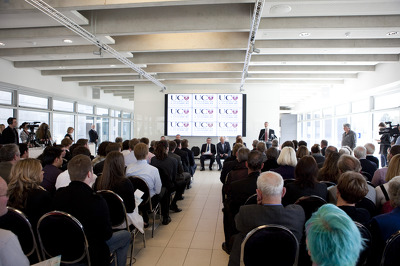
Vice-Chancellor Rod Carr speaks at the Community Engagement Awards.

A map showing the new route for the Santa Parade.

An infographic showing the planned revamp of Rugby League Park.

Liquefaction covering a car park in north-east Christchurch.

Workers constructing the temporary classrooms at the College of Education.

A page banner for earthquake-related articles, headed 'Our suburbs'.

A graphic showing proposed pay increases for Christchurch City Councillers.

Graphs comparing residential property prices across Christchurch and New Zealand.

A map showing the location of landfill sites in Burwood.

A page banner promoting an article about the Clarendon Tower.

A timeline for the demolition of the Hotel Grand Chancellor.

Two workers constructing a temporary classroom on the Ilam Oval,

Workers adding ceiling panels to the space under the library.