
A photograph of the cliff face along Wakefield Avenue in Sumner. It is showing signs of recent rockfall.

A photograph of cracks in the ground near Governors Bay Road.

A photograph of cracks in the ground near Governors Bay Road.

A photograph of repaired cracks on Governors Bay Road.

A photograph of a crack in the concrete pad underneath a picnic table near Governors Bay Road.

A photograph of a concrete pad under a picnic table near Governors Bay Road. The concrete has shifted in the ground.

A photograph of cracks in the ground near Governors Bay Road.

A photograph of cracks in the ground near Governors Bay Road.

A photograph of repaired cracks on Governors Bay Road.

A photograph of cracks in the ground near Governors Bay Road.

A photograph of a picnic table near Governors Bay Road. The concrete pad underneath has cracked.

A photograph of repaired cracks on Governors Bay Road.

A photograph of a picnic table near Governors Bay Road. The concrete pad underneath has cracked.

A photograph of the cliff face along Wakefield Avenue in Sumner. It is showing signs of recent rockfall.

A photograph of the cliff face along Wakefield Avenue in Sumner. It is showing signs of recent rockfall.
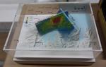
One oblong perspex covered 3-D model of the fault plains that ruptured to cause the 22 February and 13 June 2011 earthquakes; top of the model also acts as a map overlay. This model provides a visual demonstration of the geological forces that caused the 22 February and 13 June 2011 earthquakes. These forces were so strong that parts of the Por...

A photograph captioned by BeckerFraserPhotos, "Castle Rock on the Port Hills, showing where a huge section tumbled down the hillside on 22 February 2011".

Damage to the Lyttelton Port. A concrete slab has separated from the pavement. A crack has opened up and bricks at the edge are falling in.

Photograph captioned by BeckerFraserPhotos, "Kingsford Street. Look at the number of Port-a-loos and the tanks for emptying chemical toilets in this street".

An aerial view of Lyttelton a week after the 22 February 2011 earthquake. The HMZNS Canterbury, HMNZS Otago and HMNZS Pukaki can be seen at the Lyttelton Port.

An aerial view of Lyttelton a week after the 22 February 2011 earthquake. The HMZNS Canterbury, HMNZS Otago and HMNZS Pukaki can be seen in the Lyttelton Port.

An aerial view of Lyttelton a week after the 22 February 2011 earthquake. The HMZNS Canterbury, HMNZS Otago and HMNZS Pukaki can be seen in the Lyttelton Port.

An aerial view of Lyttelton a week after the 22 February 2011 earthquake. The HMZNS Canterbury, HMNZS Otago and HMNZS Pukaki can be seen in the Lyttelton Port.

Liquefaction silt surrounding a power pole in Ferry Road, next to a cut-out of a smiling and waving David Carter, National MP for the Port Hills electorate.

Liquefaction silt surrounding a power pole in Ferry Road, next to a cut-out of a smiling and waving David Carter, National MP for the Port Hills electorate.

A photograph captioned by BeckerFraserPhotos, "A view looking south along Wattle Drive, New Brighton towards the Port Hills. This part of the street is red zoned".

An aerial view of Lyttelton a week after the 22 February 2011 earthquake. The HMZNS Canterbury, HMNZS Otago and HMNZS Pukaki can be seen in the Lyttelton Port.

A photograph of a damaged footpath on Cambridge Terrace.

A photograph of street art on the wall of a building near the Wunderbar in Lyttelton. The artwork depicts Stonehenge and a rising sun in red.

Photograph captioned by Fairfax, "MP Amy Adam, left, chief financial officer, Kathy Meads, Lyttelton Port CEO, Peter Davie, and transport minister, Steven Joyce, right, with earthquake damage to Cashin Quay".