
A graph showing the decline in international student numbers in Canterbury following the 22 February 2011 earthquake.

Students leaving their lectures in the Forestry building during the progressive re-start on campus.

A graphic promoting a discussion on press.co.nz of an article titled, "Bus survivor praises her heroic rescuers".
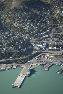
Aerial image of Lyttelton taken by the Royal New Zealand Air Force for the Earthquake Commission.

Maps showing the areas where sewers have been declared useable.
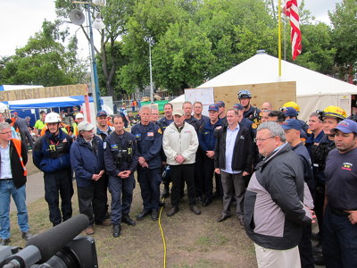
Members of the USAID Disaster Assistance Response Team (DART) photographed with their team leader, Al Dwyer, Prime Minister John Key, and Canterbury Earthquake Recovery Minister Gerry Brownlee, outside the US headquarters in Latimer Square.

A map showing the swimming water quality at Christchurch beaches.

A map showing the location of fault lines in Canterbury.

A photograph of earthquake damage to the Crown Masonic Lodge on Wordsworth Street, also known as the Freemasons Centre. The brick wall on one side of the building has collapsed, exposing the interior.

A photograph captioned by Paul Corliss, "Ferrymead Tower. Stripping the insides".

A photograph captioned by Paul Corliss, "Ferrymead Tower. Stripping the insides".

Photograph captioned by BeckerFraserPhotos, "Snow in the central city red zone. The intersection of Hereford and Manchester Streets, south-west view".

Photograph captioned by Fairfax, "Damaged building on Colombo Street in Sydenham after the earthquake on 4 September 2010".

A photograph of a worker repairing the Rendezvous Hotel. The photograph is captioned by Paul Corliss, "Central city, from Manchester Street".

Corner of Hereford Street and Manchester Street. A digger remains on the former site of Cash Converters.

A photograph captioned by Paul Corliss, "Cardboard Cathedral construction, Madras Street and Hereford Street".

A photograph of a damaged building on Tuam Street.

Photograph captioned by Fairfax, "Aftermath of the earthquake in Christchurch where the cleanup has begun. Historic buildings around Christchurch received varying degrees of damage".

Photograph captioned by Fairfax, "Christchurch Earthquake. A massive 7.4 magnitude earthquake has hit Christchurch and the wider South Island, causing widespread damage, two serious injuries and power cuts to most of the city. Landmark Kaiapoi store, Blackwell's department store, is pulled down after the earthquake - the store was deemed too dangerous and the delicate demolition started immediately".

Photograph captioned by Fairfax, "Earthquake cleanup in Dallington. Transport Minister Steven Joyce and other officials inspecting damage on Avonside Drive at Dallington".

Photograph captioned by Fairfax, "Major earthquake hits Christchurch. The Valley Inn in Heathcote gets demolished".

Photograph captioned by Fairfax, "Seabreeze Close, Bexley. Rupen Sharma and wife Lalita".

Photograph captioned by Fairfax, "Ground features. Sue Irvine's Halswell property was flooded by sand volcanoes and included bubbled-up areas of earth".

Photograph captioned by BeckerFraserPhotos, "Victoria Street".

Photograph captioned by BeckerFraserPhotos, "The Twisted Hop on Poplar Lane".

Demolition along Kilmore Street. A digger can be seen as well as a construction worker with a high hat and high-visibility vest. The rubble has been separated into different piles.

Students making use of the work and computer spaces in the reopened library.

Aerial image of Sumner taken by the Royal New Zealand Air Force for the Earthquake Commission.

Photograph captioned by Fairfax, "Oxford Area School pupil John-Ross Hovell (15) designed a homemade seismograph which has recorded every aftershock since 4 September. Photographed here with his 10 year-old sister Sarah".

An aerial photograph captioned by BeckerFraserPhotos, "Looking south-east along High Street towards CPIT".