Images from an Unstable Period
Paul Corliss has contributed over 3,000 photographs to the UC CEISMIC archive. He talks here about his earthquake experiences and why he took the photos.
Among the hundreds of abiding recollections of the two critical earthquakes is of pulling aside my curtains in the pitch black after the 2010 7.1 quake and gazing in wonder at the long stream of car lights, nose to tail, weaving their slow way from the Spit and Brighton towards Christchurch. Initially I couldn't quite figure out what rationale may have triggered what appeared to be a rapid and mass evacuation - our house seemed to be still standing (it looks out over the estuary and the Spit from Mt Pleasant). Then it hit me like a physical slap in the face that the only thing that made any sense was that there must have been a tsunami warning. It was about then that what, up until now, had been simply a post-earthquake concern was instantly ramped up to dawning realisation of the dire possibilities, a real dread.
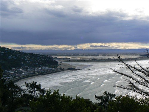
A view of Sumner and the estuary taken before the
earthquakes
The February 2012 6.3 event, for all the nightmares that still hover in the shadows, is actually a memory of 5 hours of trying to drive home from the university, Ilam Campus, through the chaos of constant shudders and thumps, every car in Christchurch seemingly mobile, the liquefaction madness pouring down the roads like rivers, and trying to establish a route where the bridges (Avon and Heathcote rivers) were still intact or not slumped or risen 3 or 4 feet into the air. The enduring memory is, perhaps surprisingly, one of the positivism of human nature. The entire, bizarre, fairground ride of a journey was pleasantly highlighted by an unexpected display of relative calm and courtesy, and numerous acts of individual compassion and support. I don't recall a single car horn or voice barked in anger. The waving through of vehicles at uncontrolled intersections (which was them all) by ultra-courteous fellow drivers; the constant and reassuring attempted humour by a lift of the eyebrows and a slightly tight smile to neighbouring cars whenever a huge thump set the vehicles juggling like 2-ton balls; residents coming from their shattered homes to try and create some order at the same intersections; passing strangers passing on advice ("the bridge is down at such-and-such street, don't turn right" or "I've heard the Lyttelton motorway bridge is open" or "avoid the CBD, it's a disaster zone"); a caregiver leading three special needs adults hand in hand through the thigh-deep lake that was St Albans Park and relaxing them in the madness with humour about going home to get their beach towels; an older chap on the side of Barbadoes Street, whose house had lost its chimney all over the footpath, slowly scraping the loose bricks together and delicately placing them into the wide chasm torn across the tar seal, finally forming two car-width brick bridges with his shattered chimney remnants to help the traffic continue; vehicles which were parked on the top of the roller-coaster humps of the road, sitting temporarily dry while the grey water filled the dips between to 2 feet and more and whatever lay beneath it.
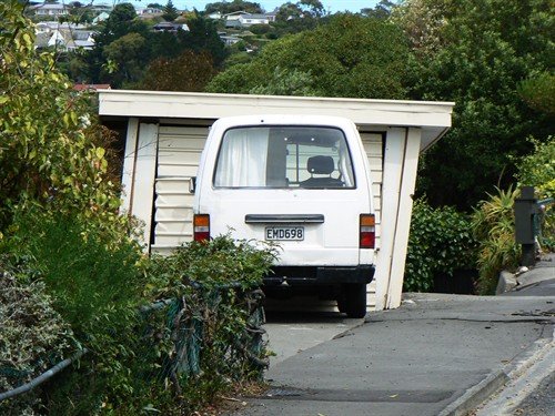 A garage on
Mount Pleasant Road
A garage on
Mount Pleasant Road
In so far as the photographs go, my motivation was reinforced by the completion of a book I had only just published in September 2010, a few short weeks before the 7.1 magnitude quake. It was a 150-year history of the five valleys - Heathcote, Morgans, Butts, Avoca and Horotane. In addition to interviews with many older residents (several of whom have since passed away), I collected and scanned hundreds of photos of the valleys and their people as they were in the historic past, and took as many more myself as they were while I was writing and researching the book. It became clear that, with Heathcote and Lyttelton bearing more of the brunt of the February 2011 earthquake and aftershocks, an enormous number of the structures and buildings had been hammered beyond repair. While the epicentre of the February quake was located under or near the port town of Lyttelton, the highest shaking recorded was under the Heathcote Valley School, an extraordinary reading of 220% of gravity. This astonishing power produced such Heathcote sights as a Station Road house being literally thrown up in the air, being ripped off its concrete foundations in the process by the sheer power, and, before it had had time to follow the law of gravity, the ground beneath it had moved two feet to one side. The house sits horizontal (tenanted, but still locked in the interminable EQC queue), but two feet out of plumb with its foundations on all sides.
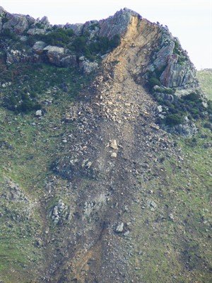
Rockfall from Castle Rock
As a result of researching the book, I realised how temporal human memories are and how undervalued photographs were beyond the generation that featured in them or took them. The list of buildings and structures destroyed and/or subsequently requiring demolition read like chapters in the book, albeit nightmare versions. Several icons coincidental to the quake were also demolished, the sky-high eye-sore blocks that were the Heathcote Maltworks silos are now a flat gravelled bed to grow a needed housing development. Some structures have been repaired like the gondola and the plinth that was levelled from on top of the War Memorial monument. Already gone, or going soon, are: the 1877 Valley Inn tavern; seemingly the large 'estate' homes of 'Aromaunga' (1914) and neighbouring 'Casterton' (originally c1853) on Bridle Path Road; the 1908 brick Pumping Station/Pumphose on Scruttons Road; the grotesquely huge and century-old gum trees that live in the memory of generations of Heathcote Valley schoolchildren; the school baths and the recently-opened bequest that was named the 'Joyce Library'; the Community Library in Martindales Road; a significant chunk shaken off the top of the prominent and all-seeing Castle Rock/Te Tihi o Kahukura, prominent on the ridgeline of the Port Hills; the Ferrymead Bridge; Tamaki Brothers' Māori Heritage Village; the shops on the corner of Flavell Street and Station Road and the shops on the corner of Port Hills Road and Martindales Road; the Heathcote Cricket clubrooms - subsequently rebuilt; the Bowling Club building - subsequently demolished; the Peter Beaven-designed road tunnel administration building and the Heathcote Community Centre. These of course ignore the countless homes of residents that are still, three and a half years later, at varying stages of repair and EQC official neglect.

Local residents watch the demolition of the Valley
Inn
Also, having close connections with and in Lyttelton, which saw by far the majority of its historic buildings levelled or torn to shreds, and Sumner and New Brighton, I soon realised that while others were without doubt doing similar work (I was aware of the Becker project) my personal perspective may be of value for future researchers and those simply with earthquake curiosity. I understood that so many buildings and associated structures figure in people's stories of their lives, myth and real events that it was important to capture them regardless of condition. When I think of all those photographs in my Heathcote book which can never be repeated or physically visited to eyeball, this reinforced a need to document what I could - it also satisfied an urge to 'stickybeak' in areas where perhaps, without a photographic purpose, I may otherwise be seen as a tad vulgar or intrusive. Other than the simple profile of a damaged or destroyed structures, I tried to capture some of the detail that was also ephemeral - like posters and signs that reflected the period post-quake, the variety of dinosaur jaws that headed the giant water-spraying demolition machines, the Gap Filler projects that sprung up then slid into gradual decay or simply the transient, administratively-endorsed, slightly gentrified, graffiti...
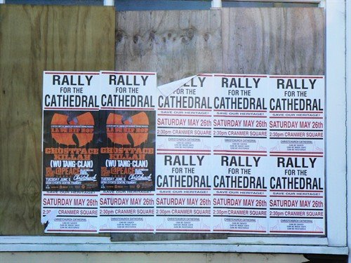
Posters advertising a rally for the ChristChurch
Cathedral
I have already drawn on my images taken during this unstable period. They filled the gaps nicely to illustrate my text in a 50-year commemorative history of the Christchurch to Lyttelton road tunnel - 'The Second Hole in the Hill'. If no one else makes use of them, this soon to be published booklet will have made all the snapping and clicking worth my while.
