FIVE
It’s hard to believe that half a decade has passed since that first earthquake shook us awake in the early hours of Saturday 4 September. Five years is a significant milestone, and one that we felt deserved a special tribute. Rosalee Jenkin from the CEISMIC team browsed the archive to find five photographs of iconic sites from the September earthquake. She then visited each site, in an attempt to re-create these photographs and compare the differences, five years on. Here is an account of her journeys.
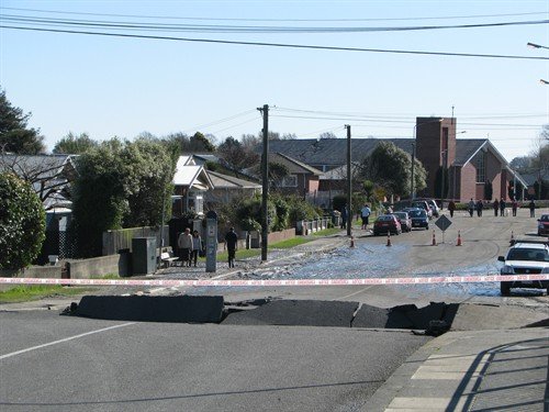
It’s a crisp, sunny morning in Kaiapoi. The noise of construction and passing traffic is immediately obvious as I hop off the bus. I can’t pretend that I know this place, in fact I don’t remember ever stopping here before. I’m definitely an outsider. The historic Mandeville Bridge is easy to find and I’m happy to see it fully restored – I wasn’t sure whether I would find it at all. Finding the exact position for the photo is another story; the trees on the bank have grown a lot in five years, and I have to fight my way through some branches to line up the shot. Afterwards, I walk over it, noticing name plates on the lamp posts – one at each end, gleaming gold in the morning light.

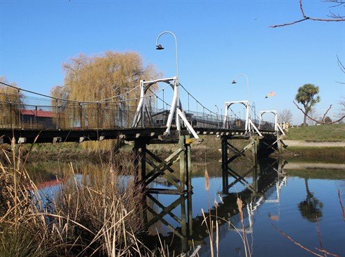
Top: Mandeville Bridge, 2010. UC Civil and Natural Resources Engineering: Creative Commons BY-NC-ND 3.0
Bottom: Mandeville Bridge, 2015. Rosalee Jenkin: Creative Commons BY-NC-ND 3.0 NZ. The building with the red roof to the left is the Kaiapoi Working Men’s Club and MSA. The grey building in the centre background is the rebuilt Mandeville Tavern.
My next stop is Blackwells department store - a five-minute walk away, on the corner of Williams Street and Ravens Quay. Like the bridge, it’s in much better shape five years on! I chat to a friendly woman behind the counter, who points out the line on the floor where the small portion of the original building ends, “All the rest has been rebuilt”. She gives me the backstory. Apparently a decision had just been made to save the original building, when the February quake hit. Further damage meant this was no longer an option, and demolition started later that month. The store continued to operate from two locations throughout all of this (one being the southern part of the building, while construction of the north-facing section was underway!) and all staff remained employed. The rebuild was then finished in 2013 and the store has been doing well ever since.
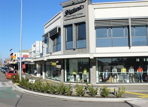
Top: Blackwells Department Store, 2010. BeckerFraserPhotos: Creative Commons BY-NC 3.0
Bottom: Blackwells Department Store, 2015. Rosalee Jenkin: Creative Commons BY-NC-ND 3.0 NZ
Although this is also my first visit to Hororata, it feels strangely familiar, having archived many photos of cracked roads and paddocks, the historic homestead, and of course St John’s church. This is the third site I’ve chosen to photograph, because of its significance to the community. It’s eerily quiet here, and the heavily overcast sky contributes to an overall sombre feeling as I position the camera lens through the fence. The little brick church stands patient and lonely in the field, now with a boarded-up spire to protect it from the elements, but not yet safe enough to have people inside. I stop for a coffee at the Hororata café, and find myself feeling relieved for the staff that I’m not their only customer. I learn that the parish have launced a fundraising appeal to restore and strengthen the building, and are determined to bring back the heart of their community.

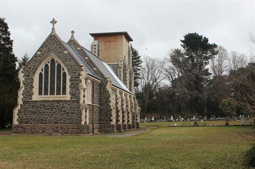
Top: St John’s Church in Hororata, 2010. BeckerFraserPhotos: Creative Commons BY-NC 3.0
Bottom: St John’s Church in Hororata, 2010. Rosalee Jenkin: Creative Commons BY-NC-ND 3.0 NZ
The Gayhurst Road bridge in Dallington is the most surreal of the sites I have visited by far. I’m on my bike, and beginning to second-guess whether I’m actually in the right place, given the complete lack of landmarks and the expansive paddocks which look like they have always been there. I end up cycling further down the road for ten minutes, half expecting there to be another bridge with another bend in the road just after it, and some sort of indication that a church – namely St Paul’s Catholic Church and School – had once stood there. But there’s nothing, so I turn around and head back to the dairy on the corner of Avonside Drive. I show the man behind the counter the photo from 2010, asking if this is in fact the road where St Paul’s church was. He confirms I’m in the right place, and I marvel at how much it’s changed. It’s not only the church and school that have gone, but an entire street of houses. Some online research later reveals that half of the residents of this area have been red zoned, and according to the 2013 census there are less than 426 homes left [1]. This is no longer a neighbourhood, but a thoroughfare; the road is still busy, but no one is stopping. I’m pleased to see brand new separated cycle ways though, and although it’s not the most scenic route at present – just construction sites and empty paddocks – there is potential to rejuvenate this area, with people like the Avon Otakaro group already working to turn their vision of an ecological and recreational reserve into a reality.
[1] CCC, Community profile – November 2014 Avondale / Dallington
Top: Gayhurst Road bridge, 2010. Mark Lincoln: Creative Commons BY-NC-ND 3.0 NZ
Bottom: Gayhurst Road bridge, 2015. Rosalee Jenkin: Creative Commons BY-NC-ND 3.0 NZ
My final destination is somewhere much more familiar – the corner of Manchester and Worchester Streets where Westende Jewellers stood. I probably walk through this intersection on a weekly basis, but this doesn’t actually make it any easier to figure out where I am supposed to be photographing. I start second-guessing myself again – is it this corner or the opposite one? I just assumed that I would remember where the store stood once I got there, but both corners are completely barren and the lack of buildings is quite disorientating. The traffic lights end up being my reference point, and I use a road cone as a tripod. I realise that all of this mess – the road cones, the scaffolding, the hurricane fencing and the construction vehicles – has become practically invisible to me these days. This is the new norm. It’s as if I have compartmentalised the pre-quake Christchurch from post-quake Christchurch – both exist as separate places in my head and it’s not until I try to overlap them by pinpointing specific things that the craziness of it all really sets in.

Top: Westende Jewellers, 2010. Copyright, Fairfax Media. Used with permission. Photo credit: Iain McGregor
Bottom: Former site of Westende Jewellers, 2015. Rosalee Jenkin: Creative Commons BY-NC-ND 3.0 NZ
As I’m heading back to the new bus interchange, a guy on a bicycle with a charming accent asks me where the nearest bank is. I tell him there are a couple at Re:START mall, and proceed to give him directions. As he waves thanks and cycles off, I’m still experiencing a heightened awareness of the chaos that is central Christchurch right now – a view of our city that a visitor might have, perhaps. There’s no doubt that it’s a bit of a mess right now, but then rebuilding a city is no small task. Five years has gotten us a clean slate, now it’s time to fill it.