Expanding the Heritage New Zealand Collection
UC CEISMIC is excited to announce the addition of a collection of over 3000 photographs from Heritage New Zealand to the archive this week. They are to sit alongside the other material in Heritage New Zealand's collection, including over two hundred archaeological reports on pre-1900 sites in Christchurch, over one hundred register records of historic places damaged beyond repair by the Canterbury earthquakes, and Heritage New Zealand's submissions to the Canterbury Earthquakes Royal Commission.
Heritage New Zealand, formerly New Zealand Historic Places Trust, is an autonomous Crown Entity and is New Zealand's leading national heritage agency. Heritage New Zealand works to promote the identification, protection, preservation and conservation of the historical and cultural heritage of New Zealand.
Severe damage to heritage places caused by the Canterbury earthquakes of 2010 and 2011 has meant unprecedented and rapid loss of heritage buildings, particularly in central Christchurch but also Lyttelton and Waimakariri and Selwyn Districts. The aim of the Heritage New Zealand-UC CEISMIC partnership is to preserve as much material documenting pre-earthquake Canterbury as possible for use by future generations.
The photographs added to the collection this week are of earthquake-damaged heritage buildings. Following the earthquake on 22 February 2011 Heritage New Zealand commissioned archaeological consultants to undertake photographic recording of heritage buildings in the CBD. These buildings were predominantly pre-1900 and many were entered in the New Zealand Historic Places Trust Register and/or listed on the Christchurch City Council plan. Special attention was placed on the architectural elements of the buildings, such as columns, facades, roofs, and details around windows and doors. The photographs currently available were taken by Underground Overground Archaeology Ltd and were the result of challenging work in response to a civil defence emergency and being faced with a dangerous and changing environment within the cordon.
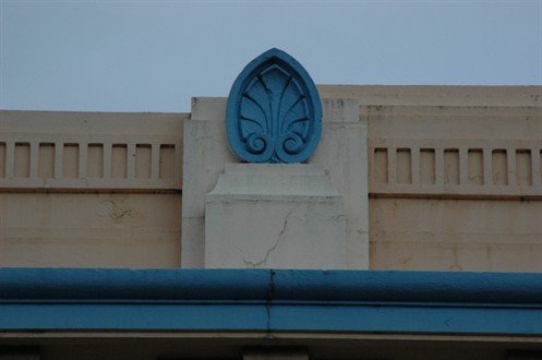 A photograph of a detail of
the Union Centre Building on Armagh Street
A photograph of a detail of
the Union Centre Building on Armagh Street

A photograph of the finial on top of one of the spires of the
Cranmer Centre
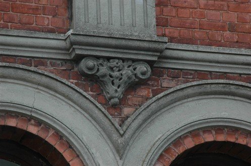
A photograph of a detail of 386-400 Colombo Street
Each of the photographs has been geolocated by UC CEISMIC. The map below helps not only to visualise the collection but also the many heritage places which have been affected by the earthquakes in Christchurch. This is something that has become increasingly difficult to visualise at ground level, as often large blocks of buildings have been removed and few familiar landmarks can be found for reference points.

Map of Heritage New Zealand photograph locations
Photographs such as these help to document Christchurch's architectural history and ensure that knowledge about our heritage is not lost entirely. This is something which has become increasingly important as more heritage buildings have been demolished and people's memories of Christchurch places begin to fade. The Heritage New Zealand collection is the most detailed record of heritage places within UC CEISMIC and an incredible resource for future generations.