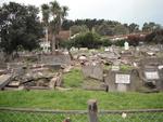
One landscape colour digital photograph taken on 30 June 2011 showing earthquake damage to graves in Lyttelton Roman Catholic and Dissenters (Public) Cemeteries in Reserve Terrace. Most of the headstones and grave surrounds in the photograph show damage. Looking east in the Dissenters (Public) section of the cemetery. The Lyttelton cemeteries a...

One landscape colour digital photograph taken on 30 June 2011 showing earthquake damage to a section of retaining wall in Sumner Road. Plastic sheeting installed to stabilise previous damage and protect from water erosion is visible to the right of the photograph. Also visible in the photograph is a boarded up broken window and temporary safety ...

One landscape colour digital photograph taken on 15 June 2011 showing earthquake damage to the Anglican Church of The Most Holy Trinity in Winchester Street, Lyttelton. Photograph shows collapsed roof of the nave and north transept. Photograph taken from the northwest corner of the church. Architect The collapse of the Church of the Most Holy Tr...

One portrait colour digital photograph taken on 25 February 2011 showing earthquake damage to the Catholic Church of St Joseph the Worker in Winchester Street Lyttelton. Photograph shows the main doors and roof at southern end of church. Nineteenth century stone buildings are particularly vulnerable to earthquake damage as the individual compon...

A hardcover book that details in words and photographs the response of the New Zealand Army, Air Force and Navy to the 22 February 2011 earthquake.

Telegraph Road was a straight road before the recent 7.1 magnitude earthquake. The fault ran right through here and now the road has a dramatic kink in it.

The September Canterbury earthquake. These pictures were taken of Colombo Street in Sydenham. A lot of masonry in this area has been damaged/fallen down.
The New Zealand Army, along with Police, were minding the cordons.
Note: these photos were taken on a cellphone; mind the quality.

The September Canterbury earthquake. These pictures were taken of Colombo Street in Sydenham. A lot of masonry in this area has been damaged/fallen down.
The New Zealand Army, along with Police, were minding the cordons.
Note: these photos were taken on a cellphone; mind the quality.

The September Canterbury earthquake. These pictures were taken of Colombo Street in Sydenham. A lot of masonry in this area has been damaged/fallen down.
The New Zealand Army, along with Police, were minding the cordons.
Note: these photos were taken on a cellphone; mind the quality.

The September Canterbury earthquake. These pictures were taken of The New Zealand Army, along with Police, minding the cordons. This was beside The Press building, and behind the Christchurch Cathedral.
Note: these photos were taken on a cellphone; mind the quality.

The September Canterbury earthquake. These pictures were taken of Colombo Street in Sydenham. A lot of masonry in this area has been damaged/fallen down.
A second hand dealer store. This is next to Penny Lane which had to relocate down the street.
Note: these photos were taken on a cellphone; mind the quality.

The September Canterbury earthquake. These pictures were taken of Colombo Street in Sydenham. A lot of masonry in this area has been damaged/fallen down.
The New Zealand Army, along with Police, were minding the cordons.
Note: these photos were taken on a cellphone; mind the quality.

An image from a Navy Today April 2011 article titled, "Earthquake!". The image is of sailors off loading food from the HMNZS Canterbury for the Lyttelton Community.

Aftermath of September 4th Earthquake in Canterbury (area covers Christchurch City) NZ. Storm drains - Anfield Street, Brooklands.

Aftermath of September 4th Canterbury Earthquake in NZ. Petrol station on Pages Road, Bexley, Christchurch.

Canterbury Earthquake 04/09/10
Christchurch
New Zealand

Canterbury Earthquake 04/09/10
Christchurch
New Zealand

Canterbury Earthquake 04/09/10
Christchurch
New Zealand

Canterbury Earthquake 04/09/10
Christchurch
New Zealand

Canterbury Earthquake 04/09/10
Christchurch
New Zealand

Canterbury Earthquake 04/09/10
Christchurch
New Zealand

A photograph of the Animal Rescue Unit loading vehicles with food supplies to be dropped off at welfare centres and other sites in earthquake affected areas after the 22 February 2011 earthquake.

Oil and mixed media (ground up bricks and mortar and cordon tape) painting of an army woman (Private Rachel Crins of the 2nd Canterbury NMWC Battalion) behind a cordon restricting access to building damage from September 4, 2010 Canterbury earthquake.

One right front black Mazda CX7 car door damaged during the 22 February 2011 earthquake. This panel once belonged to a Mazda CX7 car that was crushed by falling rubble during the 22 February 2011 earthquake. Considerably bent out of shape, it demonstrates the potential danger from falling masonry during an earthquake. The spray painted markings...

One red and black plastic-backed fabric uniform badge commemorating the Christchurch earthquake; badge has a red background with a black circular inset inside of which is a map of New Zealand in white with red concentric circles emanating from the Canterbury region. Across the top run the words 'Christchurch Earthquake 2011' and along the bottom...

One landscape colour digital photograph taken on 25 February 2011 showing earthquake damage to the Catholic Church of St Joseph the Worker in Winchester Street Lyttelton. Photograph shows the eastern side of the church. Photograph taken from St Davids Street. The earthquake damaged eastern wall of the Catholic Church of St Joseph the Worker sho...
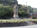
One landscape colour digital photograph taken on 1 March 2011 showing earthquake damage to the Lyttelton Cenotaph on Simeon Quay. Designer The New Zealand Flag at the Lyttelton War Memorial, along with those around the country, flew at half mast for several days following the 22 February 2011 earthquakes. Following further aftershocks the Cenota...

One portrait colour digital photograph taken on 1 March 2011 showing earthquake damage to the Dry Dock Pump House. Photograph taken from Dampiers Bay Pile Moorings showing the eastern end of the building and the Cassion. Engineer The brick pump house for the Lyttelton Graving or Dry Dock was damaged in the 22 February 2011 earthquake. Lyttelton...

Damage from the Christchurch 7.1 earthquake on 4th Sept 2010

2010-4232 Christchurch earthquake 7.1M 4 Sep 10